Lake Urmia
| Lake Urmia | |
|---|---|
 |
|
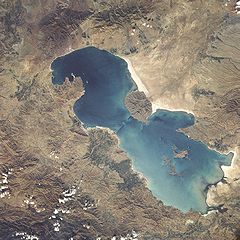
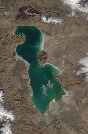
| from space, 1984 | |
| Lake type | salt (hypersaline) lake |
| Primary outflows | evaporation |
| Basin countries | |
| Max. length | 140 km (87 mi) |
| Max. width | 55 km (34 mi) |
| Surface area | 5,200 km2 (2,000 sq mi) |
| Max. depth | 16 m (52 ft) |
| Islands | 102 (see list) |
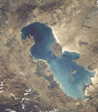
Lake Urmia (Azerbaijani: ,Urmu Goluاورمیه گولو , اورمیه گولی;Persian: دریاچه ارومیه Daryâcheh-ye Orumiyeh; , ancient name: Lake Matiene)[1][2] is a salt lake in northwestern Iran, near Turkey. The lake is between the provinces of East Azerbaijan and West Azerbaijan, west of the southern portion of the similarly shaped Caspian Sea. It is the largest lake in the Middle East[3], and the third largest salt water lake on earth, with a surface area of approximately 5,200 km² (2,000 mile²), 140 km (87 miles) length, 55 km (34 miles) width, and 16 m (52 ft) depth.
Contents |
History
One of the early mentioning of Lake Urmia is from the Assyrian records from 9th century BCE. Here from the records of Shalmaneser III (reign 858-824 BCE) two names (place or tribe name) of Parsuwash and Matai are mentioned in the area of Lake Urmia. It is not completely clear what are the identities of these names and subsequent personal names and "kings". But Matai's are Iranian Median and linguistically the name "Parsuwash" matches perfectly with the Old Persian pārsa- an Achaemenid well-known ethno-linguistic designation.[4] Based on certain historical outline of how and when the Iranian people immigrated to the Iranian Plateau in several waves along different routes, Old Persian language- the ancestor of Modern Persian was originally spoken by the people of/from "Parsuwash" who settled in Iranian Plateau sometime in early 1st millennium and finally moved down into an area where Achaemenid history began ca. 600 BCE.[4]
The lake is named after the provincial capital city of Urmia, originally a Syriac name meaning city of water. It was called Lake Rezaiyeh (Persian: دریاچه رضائیه) in the early 1930s after Reza Shah Pahlavi, but the lake was renamed 'Urmia' in the late 1970s. Its ancient Persian name was Chichast (meaning, "glittering"--a reference to its glittering mineral particles suspended in the lake water and its shores). In the medieval times it came to be known as Lake Kabuda, or "azure," in Persian, (Gabod in Armenian).
Lake Matianus (Latin: Lacus Matianus) is an old name for Lake Urmia. It was the center of the Mannaean Kingdom, a potential Mannaean settlement represented by the ruin mound of Hasanlu was on the south side of Lake Matianus. Mannae was overrun by a people who were called Matiani or Matieni, an Iranic people variously identified as Scythian, Saka, Sarmatian, or Cimmerian. It is not clear whether the lake took its name from the people or the people from the lake, but the country came to be called Matiene or Matiane.
The lake is marked by more than a hundred small rocky islands, which are stopover points in the migrations of various kinds of wild bird life (including flamingos, pelicans, spoonbills, ibises, storks, shelducks, avocets, stilts, and gulls). The second largest island, Kaboudi, is the burial place of Hulagu Khan, the grandson of Genghis Khan and the sacker of Baghdad.
By virtue of its high levels of salinity, the lake does not sustain any fish species. Nonetheless, Lake Urmia is considered to be one of the largest natural habitats of Artemia, which serve as food source for the migratory birds such flamingos. Most of the area of the lake is considered a national park.
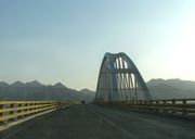
The lake is a major barrier between two of the most important cities in West Azerbaijan and East Azerbaijan provinces, Urmia and Tabriz. A project to build a highway across the lake was initiated in the 1970s but was abandoned after the Iranian Revolution of 1979, having finished a 15 km causeway with an unbridged gap. The project was revived in the early 2000s, and was completed in November 2008 with the opening of a 1.5 km bridge across the remaining gap[5]. However, the high saline environment is already heavily rusting the steel on the bridge despite anti-corrosion treatment.
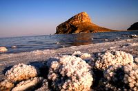
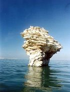
Lake Urmia has been shrinking for a long time, with an annual evaporation rate of 0.6m to 1m (24 to 39 inches). The lake's salts are considered to have medical effects, especially as a cure for rheumatism. Lake Urmia is a UNESCO Biosphere Reserve.
Chemistry
The main cations in the lake water include Na+, K+, Ca2+, Li+ and Mg2+, while Cl–, SO42–, HCO3– are the main anions [18]. The Na+ and Cl– concentration is roughly 4 times the concentration of natural seawater. Sodium ions are at slightly higher concentration in the south compared to the north of the lake, which could result from the shallower depth in the south, and a higher net evaporation rate.
The lake is divided into north and south parts separated by a causeway in which a 1500m gap provides little exchange of water between the two parts. Due to drought and increased demands for agricultural water in the lake's basin, the salinity of the lake has risen to more than 300 g/L during recent years, and large areas of the lake bed have been desiccated. Therefore, management and conservation of this incomparable ecosystem should be considered to improve the current condition by fisheries research institutes.
Ecology
The Orumieh Lake, which lies in the northwestern Iran, is home to some 212 species of birds, 41 reptiles, 7 amphibians, and 27 species of mammals, including the Iranian yellow deer. Experts have warned that the construction of a 1.5 kilometer bridge over the lake, finished a few months ago, together with a series of ecological factors, will eventually lead to the drying up of Orumieh, turning it into a salt marsh which will directly affect the climate of the region.
The construction of a dam on part of the lake and the recent draught has significantly decreased the annual amount of water Orumieh receives.This in turn has increased the salinity of Orumiyeh's water, causing the lake to lose its significance as home to thousands of migratory birds, such as flamingoes.
Palaeoecology
A palynological investigation on long cores from Lake Urmia has revealed a nearly 200 kyr record of vegetation and lake level changes. The vegetation has changed from the Artemisia/grass steppes during the glacial/stadial periods to oak-juniper steppe-forests during the interglacial/interstadial periods. The lake seems to have had a complex hydrological history and its water levels have greatly fluctuated in the geological history. Very high lake levels have been suggested for some time intervals during the two last glacial periods as well as during both the Last Interglacial as well as the Holocene. Lowest lake levels have occurred during the last glacial periods.
Islands
Lake Urmia has 102 islands[7]. Their names are as follows: (For a Persian transcription of this list see this link).
Aram, Arash, Ardeshir, Arezu, Ashk, Ashk-Sar, Ashku, Atash, Azar, Azin, Bahram, Bard, Bardak, Bardin, Bastvar, Bon, Bon-Ashk, Borz, Borzin, Borzu, Chak-Tappeh, Cheshmeh-Kenar, Dey, Espir, Espirak, Espiro, Garivak, Giv, Golgun, Gordeh, Gorz, Iran-Nezhad, Jodarreh, Jovin, Jowzar, Kabudan (Qoyun daghi), Kafchehnok, Kakayi-e Bala, Kakayi-ye Miyaneh, Kakayi-e Pain, Kalsang, Kam, Kaman, Kameh, Kariveh, Karkas, Kaveh, Kazem-Dashi, Kenarak, Khersak, Kuchek-Tappeh, Magh, Mahdis, Mahvar, Markid, Mehr, Mehran, Mehrdad, Meshkin, Meydan, Miyaneh, Nadid, Nahan, Nahid, Nahoft, Nakhoda, Navi, Naviyan, Omid, Panah, Penhan, Pishva, Sahran, Samani, Sangan, Sangu, Sarijeh, Sepid, Shabdiz, Shahi (Eslami), Shahin, Shamshiran, Shur-Tappeh, Shush-Tappeh, Siyavash, Siyah-Sang, Siyah-Tappeh, Sorkh, Sorush, Tak, Takht, Takhtan, Tanjeh, Tanjak, Tashbal, Tir, Tus, Zagh, Zar-Kaman, Zarkanak, Zar-Tappeh, Zirabeh.
Basin Rivers
- Aji Chay
- Ghaie River
- Alamlou River
- Leylan River
- Zarrineh River
- Simineh River
- Gadar River
- Mahabad River
- Barandouz River
- Shahar River
- Nazlou River
- Rozeh River
- Zola River
References
- ↑ Henry, Roger (2003) Synchronized chronology: rethinking Middle East antiquity : a simple correction to Egyptian chronology resolves the major problems in biblical and Greek archaeology Algora Publishing, New York, p. 138, ISBN 0-87586-191-1
- ↑ E.J. Brill's first encyclopaedia of Islam, 1913-1936 Volume 7 page 1037 citing Strabo and Ptolemy.
- ↑ Britanica
- ↑ 4.0 4.1 cf. Skjærvø, Prods Oktor (2006), "Iran, vi(1). Earliest Evidence", Encyclopaedia Iranica, Vol. 13
- ↑ http://www.payvand.com/news/08/nov/1165.html
- ↑ http://www.salinesystems.org/content/2/1/9 Saline Systems; Urmia Salt Lake, Iran
- ↑ List from: Farahang-e Joghrafiyayi-e shahrestânhâ-ye Keshvar (Shahrestân-e Orumiyeh), Tehran 1379 Hs.
External links
- Saline Systems; Urmia Salt Lake, Iran
- Profile at UNESCO Biosphere Reserve Directory
- Lake level fluctuations in the geological history
- Late Pleistocene vegetation changes in NW Iran
|
||||||||||||||||||||